
Thursday wildfire update from EOC

By Emergency Operations Centre
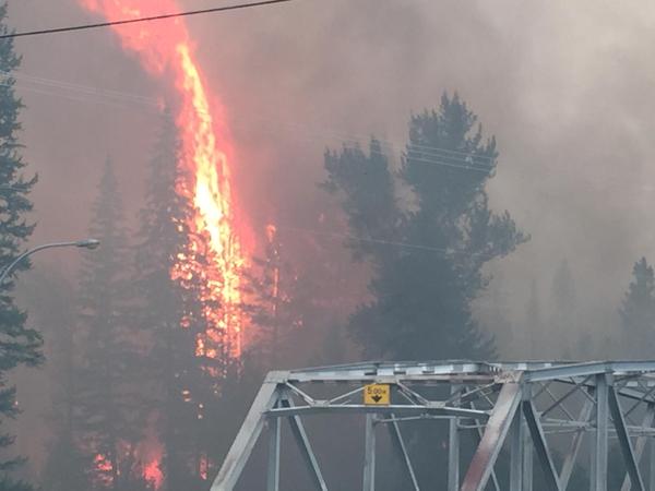
Wildfire Update for August 27, 2015.
Lynch Creek:
· This fire is located 25km north of Grand Forks and is approximately 250ha and 15% contained.
· The BC Fire Service is working on containment of the east flank of this fire.
· This fire is currently not threatening any structures or communities, however smoke from this fire is visible to the residents in the North Fork region.
· A public access restriction is in effect immediately for the Gladstone Forest Service Road due to the high fire danger rating and adjacent wildfires. This restriction takes effect immediately and will remain in force until the public is otherwise notified.
· This area restriction order applies to Crown land within the geographic boundaries outlined below:
The Gladstone Forest Service Road at the junction with Lynch Creek Forest Service Road as indicated on the attached map.
BC Wildfire Service Lynch Creek Fire Information Page – August 26, 2015 at 3:34 PM http://bcwildfire.ca/hprScripts/WildfireNews/OneFire.asp?ID=579
Stickpin Fire:
· The BC Fire Service is monitoring the winds that are impacting the direction of the fire. The fire is approximately 19,570ha and 17% contained.
· Significant resources are being mobilized to Christina Lake in preparation should the winds push the fire to the north-east.
· On Sunday August 23rd, 33 BC Wildfire Service Firefighters and 3 Officers began fire suppression activities on the Stickpin Wildfire in North Ferry County, Washington. They are responsible for Branch 3, also known as the Canadian Branch, on the Northeast potion of the fire. Objectives included developing situational and operational awareness for the first days on the fire, identifying fire lines, and determining strategies and tactics moving forward.
· On Monday august 24, crews continued to create guard lines and fuel free areas on the north east side of the fire, and began preparing for burn off operations along these lines. There was some minimal growth on the north west side of the fire on Sunday August 23rd. Crews made good progress towards containing this growth.
· If required, BC Wildfire Service air tankers may use Christina Lake for air operations. An Air Attack Officer flying in a smaller “bird-dog” or lead aircraft may sound an alarm over the area prior to air tankers landing in the lake. For the safety of firefighting personnel and the public, recreational boaters are asked to avoid using the lake during these operations. Safe fire suppression efforts depend on the support and understanding of the public.
· The BC Wildfire Service is working with structural protection firefighters from the Boundary region to assess properties which could potentially become threatened by this wildfire. Residents will be notified if an Evacuation Alert or Order is put in effect.
US Incident Reporting http://inciweb.nwcg.gov or
BC Wildfire Service Stickpin Fire Information Page – Last Update August 26, 2015 at 4:03 PM
http://bcwildfire.ca/hprScripts/WildfireNews/OneFire.asp?ID=580
Rock Creek Fire:
· The fire is approximately 4,534ha and is 75% contained.
· Ministry of Agriculture is working with farmers to restore internet services so supplies can be ordered for livestock.
· Smokey conditions are heavy in the Midway, Greenwood and Rock Creek areas. Much of the smoke is originating from fires in Washington State. To see a smoke forecast for western Canada, visit http://www.bcairquality.ca/bluesky/west/index.html
· This area contains multiple potential hazards, including active wildfire, “danger trees” (trees whose root systems have been weakened by fire activity), heavy equipment use and downed power lines.
· The Regional District of Kootenay Boundary has downgraded all areas under Evacuation Order to Evacuation Alert, effective at 7:00 pm August 19th. Highway 33 is open as of August 21st at 6:00pm.
· Entering any restricted area can delay firefighting activities, contribute to the growth of the fire and possibly put more values and people at risk. Safe fire suppression efforts depend on the support and understanding of the public. The Resiliency centre remains open in Midway at:
692 7th Ave.
Midway BC
250.449.2310
BC Wildfire Service Rock Creek Fire Information Page: Last Update August 26, 2015 at 7:42 PM
http://bcwildfire.ca/hprScripts/WildfireNews/OneFire.asp?ID=569
Paulson Fire:
· The Paulson fire is currently 320ha and is 80% contained
· Crews are continuing to mop-up on the western and north flanks.
· This fire is highly visible from HWY 3. For current driving conditions in B.C, including road closures and hazards, please visit: http://www.drivebc.ca
BC Wildfire Service Paulson Fire Information Page – Last Update August 26, 2015 at 3:33 PM http://bcwildfire.ca/hprScripts/WildfireNews/OneFire.asp?ID=576
Big Sheep Creek Fire:
· The Big Sheep fire is approximately 190ha and is 60% contained.
· The south and west flanks are contained and today crews will focus on the enforcement of control lines.
· This fire is currently not threatening any structures or communities. However, smoke is visible to residents in the Sheep Creek area and the community of Rossland.
· A public access restriction is in effect for the areas around the Big Sheep Creek wildfire west of Rossland. This restriction takes effect immediately and remains in force until the public is otherwise notified.
· Public access restriction is in effect for the areas around the Big Sheep Creek wildfire west of Rossland. This restriction takes effect immediately and remains in force until the public is otherwise notified. This restriction is being put in place to protect the safety of the public and firefighting personnel and closes the Seven Summits trail at the intersection of Red Resort to the intersection at the Old Cascade Highway. The Seven Summits trail remains open from the Nancy Greene Summit to Red Mountain Resort.
BC Wildfire Service Big Sheep Creek Fire Information Page – Last Update August 26, 2015 at 3:36 PM http://bcwildfire.ca/hprScripts/WildfireNews/OneFire.asp?ID=578
Important Links
· http://bcwildfire.ca/hprScripts/WildfireNews/FireCentrePage.asp
· EmergencyInfoBC Online source for emergency alerts about natural disasters and provider of public education and preparedness information.
· DriveBC Road conditions and closures
· BC Air Quality The Air Quality Health Index is a health protection tool that is designed to help you make decisions to protect your health by limiting short-term exposure to air pollution and adjusting your activity levels during increased levels of air pollution.
· Interior Health During a forest fire, be aware of health risks associated with exposure to smoke, food safety in power outages, and water quality.
· http://inciweb.nwcg.gov USA wildfire information
· http://firesmoke.ca Wildfire Smoke information
· www.wsdot.com For Travel Alerts in the USA
Highway 33 is now open. Travel from Rock Creek to Kelowna is now possible along this highway. From Rock Creek to Beaverdell there is a 60km/h speed limit in effect. Please watch for work crews and livestock. Drivers be advised that Rock Creek to Westbridge is still an active fire area and crews are patrolling for fire activity. The BC Fire Service is aware of smoke and hot spots. Please do not report these incidences to keep phone lines open for emergencies.
Please remember to drive safely. Be aware of service and flagging crews, and fire crews that are working on our roadsides.
To contact the Emergency Operations Centre
phone 250-368-9127 or 888-747-9119
or for more information go to www.RDKB.com


Comments