Castlegar BC
Castlegar is a small city in the West Kootenay region of British Columbia, Canada. It is located within the Selkirk Mountains at the confluence of the Kootenay and Columbia Rivers. It is a regional trade and transportation centre, with a local economy fueled by forestry and tourism. It is home to Selkirk College, a regional airport, a pulp mill, and several small sawmills. The population of 7,259 people includes a large number of Doukhobors, who were largely responsible for much of Castlegar's early development and growth. A sizeable Portuguese community grew as workers, mainly from the Azores islands, moved in to take up employment in the area. The area which was to become Castlegar was an important centre for the Sinixt (Lakes) Peoples. Outside the city limits are the small surrounding communities of Blueberry, Ootischenia, Brilliant, Robson, Robson West, Raspberry, Tarrys, Thrums, Shoreacres, Fairview, Genelle, Pass Creek and Krestova. There are also the much smaller communities of Deer Park, Renata, and Syringa on Lower Arrow Lake. Taken together, these outlying areas comprise an approximate population of a further 8,000 people.
Castlegar Links
History
On September 5, 1811, David Thompson arrived at the location where Castlegar now sits, where he camped near the mouth of the Kootenay River. A plaque dedicated to David Thompson can be found on the east bank of the Columbia River overlooking the present day site of Castlegar.
The first settlement in the area was West Waterloo, now known as South Castlegar. There was widespread provincial interest in gold prospecting in the late 19th century, and by 1895 there were forty houses in Waterloo. The town boomed until the end of the century when interest in the local mines declined.
Castlegar takes its name from the Irish ancestral home of townsite founder Edward Mahon. The city was platted in 1897. Around 1902, the Canadian Pacific Railway (CPR) built the bridge at Castlegar and laid the wide gauge railway tracks to Trail. They put in a box car station at the old Waterloo trail crossing and called it Kinnaird Station in honour of Lord Kinnaird who was a shareholder in the CPR.
There was little in Castlegar until after the completion of the CPR bridge. A Mr. Farmer built the first store in town, housing both the post office and the town hall. William Gage built the Castlegar Hotel in 1908, standing until 1982 when it was destroyed by fire. Also in 1908, the first schoolhouse was built by a few local residents who bought the lumber and erected the building. A dance pavilion, garage, tourist cabins and a slaughterhouse had all been established by 1925.
On October 30, 1946, Castlegar was incorporated into a village, then in 1966 into a town. It amalgamated with the neighbouring town of Kinnaird into a city on January 1, 1974, effectively doubling the population. On May 20, 2004, the City's boundary was extended to include the Blueberry Creek Irrigation District.
Native History

Castlegar is located in the border area between the Sinixt (Interior Salish) and the Ktunaxa Indian bands. Experts cannot agree where the Ktunaxa range ended, and where the Sinixt began. There was much overlapping of cultural and territorial activity between the two peoples. Most recent information suggests that the Sinixt were the original people in the area, and that the Kootenai arrived several hundred years ago from central Canada.
"Qepitles" was a site on the north side of the Kootenay River, just above the junction with the Columbia River. The site was popular as a trading place and, especially in the autumn and winter, for spear and line fishing for salmon, which were dried nearby. Native implements (arrowheads, pestles, etc.) have been found along the nearby Arrow Lakes. A reconstructed kekuli dwelling was formally located on Zuckerberg Island, at the confluence of the Kootenay and Columbia rivers.
Doukhobor History

The Doukhobors put a ferry into operation near Brilliant on the Kootenay River in 1910 and the Christian Community of Universal Brotherhood (CCUB) made an application to the CPR for a railway station and siding to this point. Brilliant was the centre of the CCUB commercial enterprises. Located on the site was the Brilliant Jam Factory, a grain elevator, and a flax seed mill.
Airport
The West Kootenay Regional Airport is owned and operated by the City of Castlegar. The Airport has regular service to both Vancouver International Airport and Calgary International Airport. The West Kootenay Regional Airport is the center for air traffic in the West Kootenays and safely moves approximately 74,000 annually through its facility."
Schools
Castlegar has four elementary schools (Twin Rivers Elementary School, Castlegar Primary School, Kinnaird Elementary School, and Robson Community School) and a high school, Stanley Humphries Secondary School, all part of School District 20 Kootenay-Columbia.
Sports
The city's Junior "B" hockey team is the Castlegar Rebels of the KIJHL.
Other activities include The Castlegar Skating Club, Dancing at Turning Pointe Dance Studio and Scottie School of Highland Dance, Castlegar Aquanauts, Castlegar Minor Soccer, Castlegar Gymnastics Club, Baseball, Lacrosse, Golf, Curling, Tennis, Volleyball, Basketball programs, Many yoga/fitness etc. programs are offered at the Castlegar Complex. West Kootenay Minor Football Assoication, Castlegar Sentinels Football Club.
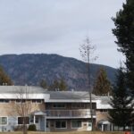
Selkirk College is also located in Castlegar
Geography
The main street, Columbia Avenue, runs the length of the City of Castlegar. It becomes Highway 22 on the South end, and the Robson Bridge at the North end. Most businesses in Castlegar are located on or just off of Columbia. There are several neighbourhoods in Castlegar, including downtown, Southridge, Oglow Subdivision, Woodland Park, Grosvenor, Kinnaird, and Blueberry Creek, among others. Outskirts of Castlegar include Robson, Robson West, Brilliant, Raspberry, Pass Creek, Ootischenia, Tarrys, Thrums, and Genelle.