UPDATED: Double-wide trailer engulfed by wild Hamill Creek as rains pummel North Kootenay Lake region
Heavy precipitation has caused structural damage to several homes on Hamill Creek north of Kaslo and impacted various other creeks throughout the region said Bill Macpherson Public Information Officer for the Regional District of Central Kootenay.
“A double wide trailer has gone downstream and another home is being eroded at the foundation on Hamill Creek just south of Meadow Creek,” Macpherson said in a statement.
“The bridge approach has been impacted, one resident was evacuated to the north side. Power lines are in the creek currently.”
The damage is mostly due to what Environment Canada calls as an upper low moving into Southern Alberta is spreading extensive moisture across Southern BC.
The system dumped rainfall in the amounts of from 30 to 50 millimetres over parts of the region.
Macpherson said other damage included one house flooded at Fletcher Creek, south of Kaslo, and a small access bridge impacted while a section of the Mirror Lake water system was impacted by debris.
The deluge of precipitation has also impacted highways in the North Kootenay Lake region.
The highway near Lardeau, 27 kilometres north of Kaslo is reduced to single lane due to a mudslide while the highway at Schroeder Creek is closed in both directions.
The Ministry of Transportation is optimistic the the highway will be pened to single lane traffic later Thursday evening.
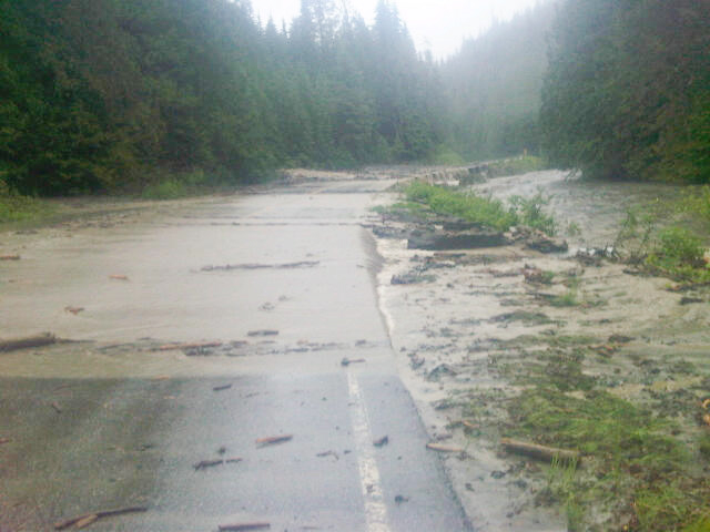
Meanwhile, Highway 31A between Kaslo and New Denver is closed at this time due to a washout. Highway crews are deteminined the next chain of events. There is no detour on this road.
In Crawford Bay, a berm at Crawford Creek has been impacted but is holding; it is being monitored on an ongoing basis.
Elsewhere, a partial dike failure on Silverton Creek is being addressed with rip-rap and equipment; a Ministry of Forests crew is assisting local personnel.
Most of the smaller creeks and watercourses have peaked as the forecast has improved slightly. Medium and larger creeks are expected to do the same if the weather forecasts hold true.
Precipitation amounts are forecast to be considerably less than over the last 48 hours.
Anyone needing assistance or reporting damage should contact (250) 352-7701.
Highway and road information is available from Drive BC by calling 1-800-550-4997.
Mudslides slow traffic on Highway 31; Highway 31A closed due to washout
Recent heaving rains are presumed to be the main cause of highway closures in the Kaslo/New Denver areas of the West Kootenay.
Early Thursday a mudslide, 13 kilometres north of Kaslo on Highway 31 reduced the road to single lane traffic.
A few kilometres north, 27 kilometres from Kaslo, a mudslide closed Highway 31 in both directions.
Crews are on the scene and Drive BC reports both sections of highways are scheduled to re-open between 11 a.m. and 2 p.m.
The road hazards affects residents in the North Kootenay Lake region, Meadow Creek, Lardeau and Johnsons Landing.
Meanwhile, traffic is not moving between Kaslo and New Denver on Highway 31A as a washout has closed the road.
No detour is available.
Highway personal are assessing the scene to determine how to open the highway.
YRB crews deal with sinkhole near Crescent Valley
Rain, rain and more rain is being blamed for a sink hole on Highway 6 near Crescent Valley Wednesday afternoon.
The sink hole, in the northbound land a kilometer south of Crescent Valley Co-op, was estimated at six-feet deep by Yellowhead Road & Bridge workers.
Traffic was reduced to single lane as YRB crews spent most of Wednesday afternoon removing soil and debris from the ditch near the sinkhole before filling and paving over the damaged highway.
The sinkhole is being blame on more than 25-35 millimetres of rain that fell on the West Kootenay Wednesday.
A Facebook posting on The Nelson Daily site said “Kokanee creek is raging today” while another posted “Feel like a duck!”
Environment Canada is continuing the heavy rainfall warning into Thursday due to an upper low moving into Southern Alberta is spreading extensive moisture across Southern BC.
Rainfall amounts so far have been in the 15 to 25 millimetresrange except over the southeast where rainfall amounts range from 30 to 50 millimetres. Additional rainfall amounts will be in the 20 to 30 millimetresrange but over the southeast amounts to 50 millimetresare possible.
Heavy rain will gradually ease over many areas on Thursday however will continue over the southeast where a further 10 to 20 millimetresis possible.
Heavy rainfall could impact creeks and streams says YRB operations manager
The Yellowhead Road & Bridge Operations Manager for the Southeast District is warning drivers of to be on the lookout for any overflowing creeks or streams during the severe rains the West Kootenay is experiencing.
Marc Dale issued the warning in a statement Wednesday afternoon.
“We are experiencing heavy rainfall throughout our area which will continue through tonight. Forecasted amounts are 25-35 millimetres with periods of intense rain,” Dale said.
“YRB are presently patrolling the roads and monitoring stream levels and culverts. We have scheduled patrols overnight to continue watching for problems that may arise.”
Environment Canada has issued a rainfall warning for the region with amounts of 40 to 60 millimetres expected to fall through Thursday.
Environment Canada adds a very moist area of low pressure is approaching Southern British Columbia bringing widespread rain into the British Columbia Interior.
With this ample supply of moisture and the slow moving nature of the low, heavy rainfalls are likely. Widespread rainfall totals of 40 to 60 millimetres are expected over a two-day period with locally higher amounts possible especially where rain is enhanced by local terrain.
















Comments