UPDATE: Snow storm slows traffic on Kootenay Pass
The storm came and went and left behind a lot of snow at the higher elevations for skiers.
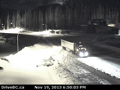
A snow advisory did not disappointed as a centemeters of snow fell at the higher elevations, including the Kootenay Pass Tuesday.
Avalanche control near the summit slowed traffic Tuesday morning.
The storm passed leaving cooler northern air flowing over the region.
Tempertures are expected to dip to minus-3 C for a few days before warming to zero later in the week.
YRB issues snow advisory for Kootenay Pass, 20-30 centimeters expected
It may be snowing in the valley bottoms but on top of the mountain passes, a la, Kootenay, Bombi and Blueberry Paulson, winter is settling in thank you very much.
Marc Dale, Operations Manager for the Southeast Kootenay Region for Yellowhead Road & Bridge, issued an advisory Monday to motorists driving the Kootenay Pass of extreme winter conditions.
“A heavy snowfall warning is forecasted for our area beginning late this afternoon and continuing throughout Monday night,” Dale said in a release.
“Kootenay Pass could potentially receive 20-30 centimeters of snow overnight.”
Dale said snow should be expected as low as 700 meters and with temperatures just above freezing expect compact snow, and slush.
“This weather system is to move into our area quickly and snow will be heavy at higher elevations,” he said. “Temperatures in the valley will dictate whether this system will be rain or snow yet expect snow. Rain will continue Tuesday.”
Dale said YRB will have plows travelling the main routes throughout the night but cautions drivers to slow down and drive to weather and road conditions.
For more information check the Drive BC website at http://www.drivebc.ca/


















Comments