Homes confirmed lost in Rock Creek fire; fire remains uncontained
BC Wildfire Service has been able to do more accurate mapping of the Rock Creek fire, which started Thursday, and has determined that 29 homes have been lost as well as an additional 11 structures.
Rock Creek Riverside Campground confirmed via their Facebook page that their home was one of the structures lost. The campground is located off Hwy. 33 near Rock Creek.
Reports are also coming in that homes may have been lost on Desmazes Road and Zamora Road, but no more details are available until all homeowners have been updated. Residents are asked to call 250-368-0254 for information about their property.
Hwy. 3 was opened Saturday night with the speed limit set to 50 km/h in some areas and a warning to watch for debris on the road. Hwy. 33 is still closed.
The evacuation order was removed from 88 homes and businesses on the Hwy. 3 corridor through Rock Creek but still remains in effect for 242 homes in the community.
Kettle River Provincial Park was the first place to be evacuated when news of the fire broke. The Regional District of Kootenay Boundary (RDKB) said that evacuees are being transported back to the Kettle River Provincial Park this afternoon to retrieve any salvageable belongings.
All evacuees are asked to check in at the Midway Reception Centre 250-449-2310.
Power in the affected areas
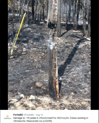
Power remain out in much of the area but are slowly being restored either by repairs or using a diesel generator, according to FortisBC.
Rock Creek, Kettle Valley Road and Kettle Valley South Road were the first to get power on Aug. 14. Beaverdell had power restored by 7 p.m. on Saturday evening using diesel-generated power but the power is expected to be intermittent.
Christian Valley power is expected to be restored tonight using a generator but the corridor from Westbridge to Rock Creek does not have a time set for when power will be restored. According to Fortis, the damage in that area is extensive.
Firefighting
Over 100 BC Wildfire Service firefighters are working in Rock Creek along with seven helicopters, 14 pieces of heavy equipment and airtankers when necessary.
The fire remains out of control, and personnel are focusing their efforts on keeping people safe and protecting structures.
BC Wildfire Service stresses that the area is not safe and the public will be putting their own lives and the lives of firefighters at risk if they enter the evacuation area.
Trees root systems become weakened by the fires and could fall, there are downed power lines in the area and people are operating heavy equipment, making it unsafe.
A public meeting will be held today (Aug. 16) at 4 p.m at the Midway Community Centre to update people on the fire.
This fire is still believed to be human-caused.
Stickpin Fire
The Stickpin fire south of the Boundary has grown again. Previous estimations had it at 8093.7 hectares (20,000 acres) but today’s estimates say it is 11081.5 hectares (27,383 acres)
The fire is burning in Colville National Park, 10 miles east of Curlew Lake and is moving north. It has crossed the Deer Creek – Boulder County Road, which is now closed.
There is a level three evacuation alert for the Long Alec, Boulder Creek/Deer Creek areas. A shelter has been set up at the Republic School.
Lone Ranch Road, Hurl But, the Danville area and the area south to Lambert Creek are asked to be ready for an evacuation while the Deadman Creek area is told to stay on alert.
This fire is believed to have been caused by lightning and has been out of control since it was discovered on Tuesday at 2 p.m. The location of the fire has made it difficult for firefighters because a safe exit route hasn’t been available for them. Other fires in the area mean firefighting resources are stretched in the region. They currently have about 300 personnel working on the fire.
Dry weather is expected to increase the fire’s activity.


Comments