Rock Creek and Washington fires growing rapidly
Update: The Stickpin fire is now estimated to be 8093.7 hectares (20,000 acres)
Edited: There was an error in the original acreage for the Stickpin part of the story and that has been corrected.
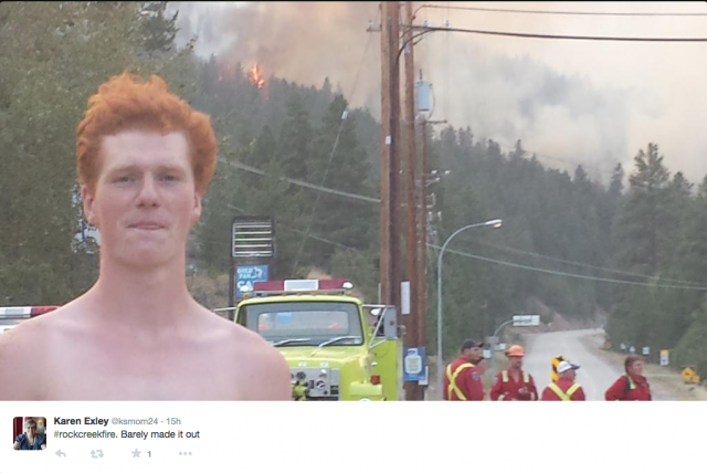
A fire that started in Rock Creek has grown overnight to encompass 2500 hectares (6177.6 acres). In comparison, Vancouver’s Stanley Park is 400 hectares (990 acres) and all the parks in Vancouver combined reach 1300 hectares.
According to the BC Wildfire Service, 76 firefighters, four helicopters, three heavy equipment and two air tankers are on the scene combatting the blaze with more on the way. The Southeast Fire Centre says they are coordinating with multiple agencies to get more help.
The fire is still listed as being zero per cent contained.
Shortly after the fire was reported at 1 p.m. yesterday, the Kettle River Provincial Park was evacuated with 200 people leaving, many only had the clothes they were wearing. Another 270 homes were evacuated in the Rock Creek, Westbridge and Christian Valley areas.
Help for evacuees
Social media has been buzzing since news of the fire was shared yesterday. People across the Boundary and beyond have been offering accommodations, food and clothing to the evacuees. Many left their camping gear, trailers and personal belongings at the campground when they were rapidly evacuated.
To consolidate the help that came flooding in, a Facebook group called Rock Creek Fire and Evacuee Information was formed where people are offering support, sharing information about loved ones and organizing relief efforts.
So far requests have come for clothing, food, blankets, pillows as well as supplies for pets.
Food delivery trucks are not able to travel on the highway so supplies are being diminished in local stores in the West Boundary, according to residents, so the demands are increasing.
The reception centre for evacuees that were sent north is the Salvation Army on 1480 Sutherland Avenue in Kelowna.
Those that went north from Westbridge and the Christian Valley were directed to the Whiteville Community Centre in Lumby at 2250 Shields Avenue.
Evacuees can call the following numbers for more information about the reception centres: Midway 250-449-2310, Kelowna 250-212-0854 or Lumby 250-549-0974.
Stickpin Fire
The Stickpin Fire south of Grand Forks in the Colville National Forest has grown overnight.
The fire, which was 1214 acres (491.3 acres) yesterday, is now 12,500 acres (5,058.6 acres) and spreading North – Northeast.
Residents in the area asked to be prepared for voluntary evacuations.
The Colville National Forest is closed, starting at the Canadian border and heading south and southwest.
Wind, low humidity and isolated thunderstorms are being blamed for the fire’s rapid expansion. They have fire crews fighting the blaze from the west but they are still struggling to fight it from other directions because there aren’t any safe escape routes for the firefighters.
The smoke from this fire is highly visible and spreading in the Boundary with Grand Forks residents reporting they can see the glow from the flames reflected on the clouds.
There were at least 35 lightning caused fires in the area last night.
The Stickpin Fire is also zero per cent contained. It is named for the Stickpin Trail in the same area.
Severe thunderstorm watch
A severe thunderstorm watch has been activated for the entire BC Interior. Environment Canada says that the conditions are favourable for severe thunderstorms that may produce strong wind gusts, large hail and heavy rain.
The warning states:
“Fast moving water across a road can sweep a vehicle away. Large hail can damage property and cause injury. Strong wind gusts can toss loose objects, damage weak buildings, break branches off trees and overturn large vehicles. Be prepared for severe weather. Take cover immediately, if threatening weather approaches. Lightning kills and injures Canadians every year. Remember, when thunder roars, go indoors!”
Yesterday residents were evacuated from Christian Valley Road to Fiva Creek, then from Rock Creek to Westbridge and the Hwy 33 corridor to the south end of Blythe-Rhone Road were evacuated. No further evacuations have been announced.
Highways 33 and 3 are closed in the area. Hwy 33 is closed from Rock Creek to Beaverdell and Hwy 3 is closed from the Anarchist Mountain Rest area (14 km East of Osoyoos) to Rock Creek and from Osoyoos to Midway. The highway is open from Grand Forks to Greenwood, but RCMP have been stopping vehicles and letting drivers know about that closures.
For RDKB evacuation information follow @AlanLStanley on Twitter. Twitter hashtags include #rockcreekfire #rockcreek and #rockcreekbc













Comments