Pack it up, pack it in: average snowpack in province favours West Kootenay
The West Kootenay is the wet Kootenay compared to the rest of the province when it comes to snow accumulation this spring.
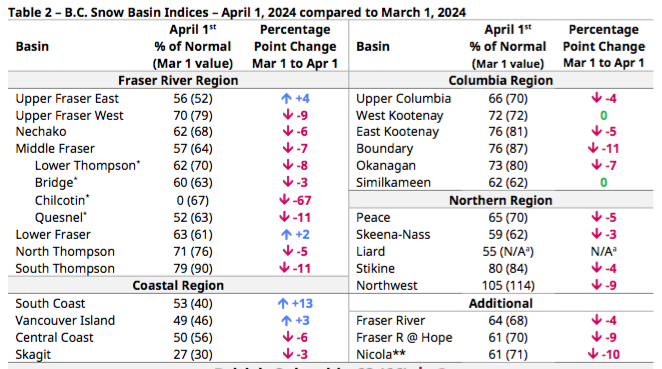
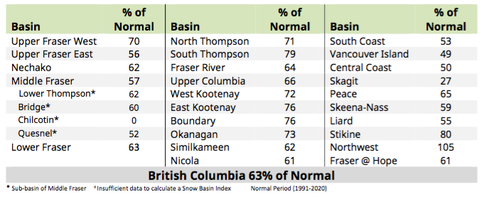
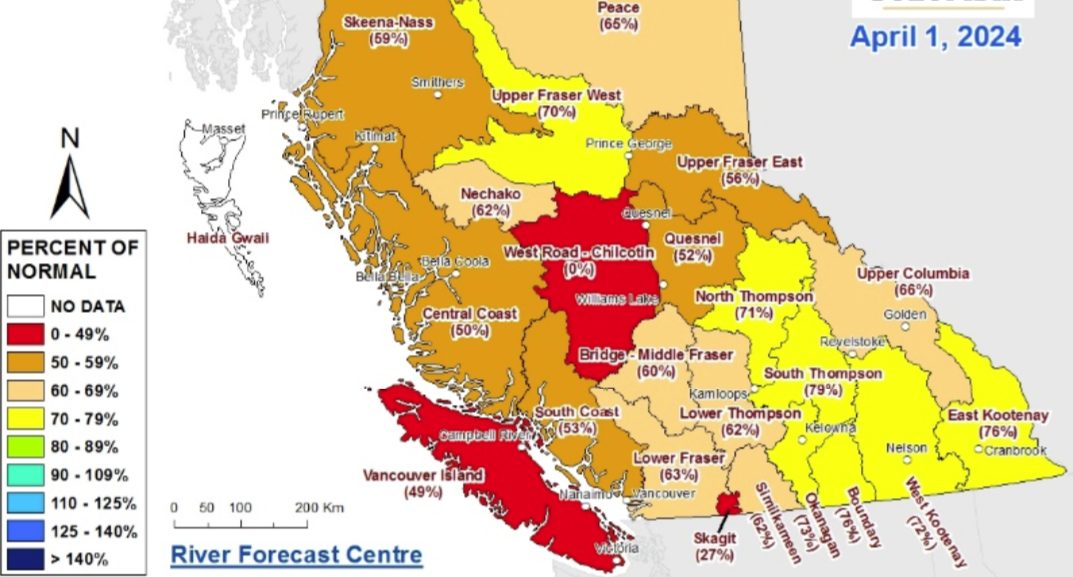
According to the Snow Survey and Water Supply Bulletin — issued by the B.C. Ministry of Water, Land and Resource Stewardship on April 1 — the West Kootenay region was sitting at 72 per cent of normal.
That figure is one of the highest in the province, with the provincial average sitting at a paltry 63 per cent — last year it was 88 per cent — the lowest average snowpack since 1970. At this time last year in the West Kootenay the average snowpack was 90 per cent.
Rain effect
Seasonal precipitation over the past 180 days has been close to normal across most of southern B.C., with a few recent rain events in the West Kootenay.
However, most of the province is mired in below normal cumulative precipitation. Overall, the provincial snowpack is extremely low for April 1, with nearly all snow basins at or below 80 per cent of normal.

Packing it in
Mid-April is when the annual snow accumulation in B.C. usually reaches maximum levels, giving a snapshot of the potential river runoff for the freshet season.
With snowpack levels well below normal across most of the province, flooding may not be the concern, the report stated.
“At this stage in the season there is no elevated flood risk present in the current snowpack across the province,” it read. “With below normal snowpack in all other regions, reduced flood risk is expected.”
It was noted that May and June were wet months through the B.C. Interior, creating the potential for extreme precipitation patterns.
While snow is one significant aspect to seasonal flooding in B.C., weather during the freshet season also plays a key role, and flooding is possible in years with near normal or low snowpack, the report stated.
Source: Snow Survey and Water Supply Bulletin

Drying it up
Low seasonal runoff forecasts could point to elevated seasonal drought hazards.
“In other areas, low snowpack and increased likelihood of early and accelerated snowmelt may contribute to an early shift in the timing of the streamflow runoff, with the influence of snowmelt runoff diminishing earlier than normal,” the report read. “It is anticipated that many regions may experience daily streamflow rates that are outside of the historical range of flows (by date), with shifts earlier in the season than usual.”
Early melt is taking place in the low-to-mid-elevation areas, with streamflow being above normal for early-April due to the early shift in snowmelt.


Comments