
UPDATED: Winter Storm warning continues for West Kootenay

By Nelson Daily Staff
Environment Canada said continued its winter storm warning for the region.
“A strong winter storm advancing from the coast has brought snow to the interior today,” the warning said.
“The snow will intensify tonight. Snowfall accumulations from this system will range from 15 to 25 cm.”
Environment Canada said there will be a break in the snow is expected early Monday morning before the next Pacific system brings a further 5 to 15 cm for late Monday into Tuesday.
“Freezing rain is also possible on Tuesday,” the warning said.
Environment Canada said drivers should consider postponing non-essential travel until conditions improve as rapidly accumulating snow will make travel difficult.
Drivers should be prepared for quickly changing and deteriorating travel conditions with surfaces such as highways, roads, walkways and parking lots will become icy, slippery and hazardous.
For information on area highways go to the Drive BC website.
Environment Canada continues weather alert for West Kootenay
Environment Canada has continued its weather alert for the West Kootenay region.
Environment Canada said the region can expect “hazardous winter conditions.”
“A strong winter storm advancing from the coast will result in heavy snow developing through the day across the warning areas,” the statement said.
“Snowfall amounts from this system will range from 15 to 30 cm. A break in the snow is expected early Monday morning before the next impulse brings a further 5 to 10 cm for late Monday into Tuesday. Freezing rain is also possible late Monday and Tuesday.
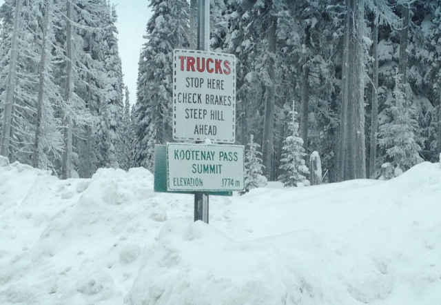
The storm is expected to impact highways — including Highway 3 from the Paulson Summit to Kootenay Pass — through most of Sunday and into the night.
Travelers should consider postponing non-essential travel until conditions improve and be prepared for quickly changing and deteriorating travel conditions.
“Surfaces such as highways, roads, walkways and parking lots may become icy and slippery,” the statement added.
“Public Safety Canada encourages everyone to make an emergency plan and get an emergency kit with drinking water, food, medicine, a first-aid kit and a flashlight.
For information on emergency plans and kits go to http://www.getprepared.gc.ca/
For more information regarding the latest forecasts and warnings can be found by going to Environment Canada at weather.gc.ca.
Environment Canada sends out alert for West Kootenay
Environment Canada has issued a Special Weather Statement for West Kootenay travelers of Highway 3, from the Paulson Summit to the Kootenay Pass for Sunday.
“A moisture-laden system moving in from the Pacific Ocean will bring a wintry mix to the western interior beginning Sunday morning,” the statement said.
“These weather conditions will spread across the rest of the central and southern interior throughout the day.”
Environment Canada said total snowfall accumulation could exceed 25 cm for both Paulson and Kootenay passes.
“The clash of this warm and moist system with the entrenched Arctic air will lead to significant snowfall in many areas,” the statement went on to say.
“As the system progress, the snow may transition to freezing rain in southern regions.”
Forecasts will be updated and any potential warnings will be issued as the exact location and snowfall amounts are determined.
The public is advised to monitor future forecasts and warnings as warnings may be required or extended.
Please monitor the latest forecasts and warnings from Environment Canada at weather.gc.ca.


Comments